Destroyed pesticide storage facilities and warehouses
Joint Stock Company "Ak-Suu Chemistry" Site Name: Joint Stock Company "Ak-Suu Chemistry" District: Ak-Suu Description of the Site:

Joint Stock Company "Ak-Suu Chemistry" Site Name: Joint Stock Company "Ak-Suu Chemistry" District: Ak-Suu Description of the Site:
78°21’58.662″E 42°32’22.061″N The wastewater treatment facilities in the city of Karakol are morally and physically worn out and require urgent reconstruction. The treatment facilities in Karakol are an environmentally hazardous site and are located with a slope towards Lake Issyk-Kul in the water protection zone of the Karakol River. The retention pond is contaminated with wastewater and, due to the accumulation of sediments, is overflowing, with the water level above the critical threshold.
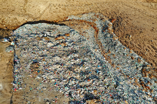
77°12’31.553″E 42°40’44.345″N The legalized, in violation of all environmental protection norms, after 12 years - the illegal dump continues to operate with virtually no proper sanitary and ecological requirements. Local residents complain about the stench from the dump, about parasites, about the constant foul smoke from self-igniting piles of rags and waste due to methane. There is a lack of drainage structures. The chain-link fence does nothing to prevent bags and trash from
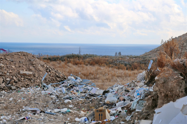
42° 39’33.209” N; 77° 07’06.345” E The recently emerged illegal dump is located near the cemetery.

42° 39’33.209” N; 77° 07’08.346” E The problem with the landfill in Cholpon-Ata has existed for several years. Residents of the region have repeatedly appealed to the local administration, writing complaints and lawsuits. According to the residents of Cholpon-Ata, the area of the landfill is increasing every day. They are outraged that waste is dumped here not only from Cholpon-Ata but also from nearby villages and boarding houses. Residents of Issyk-Kul say that every 10-15 minutes, trucks
42° 39’33.797” N; 77° 07’09.413” E In the Issyk-Kul region, there are 115 wastewater treatment facilities, including 98 in resort and health institutions, of which 29 have not been operational since 2008. The treatment facilities in the resort area of Issyk-Kul, Karakol, Cholpon-Ata, and Balykchy are morally and physically outdated and require urgent reconstruction. Every year, the number of new health institutions, organizations, cafes, and private hotels connected to the city's sewage network
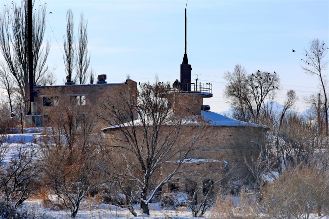
The former pesticide storage facility is located in the city of Balakchy, 300 meters from Lake Issyk-Kul. Within 200 meters of the site, there is a residential area. Despite the presence of gates at the western entrance and the facility being guarded, there are reports that agricultural animals occasionally graze on the premises. This large storage and distribution center was likely built in the 1970s and its use ceased with the collapse of the Soviet Union. The facility is now privately owned,

42° 48’10” N; 75° 58’40” E Name of the facility: Tailings Storage Facility No. 4 of the Ak-Tyuz Mining Administration Ownership (owner) of the facility: Kyrgyz-Israeli Joint Venture "Gold and Silver" Location of the facility: mouth of the Chiynike stream, right bank of the Kichi-Kemin River Region: Chui City (settlement): Ak-Tyuz settlement Height (m): 1700 Period of operation and conservation: from 1978-2008, not conserved. Current technical condition of the facility: the upper ditch

42° 51’30” N; 76° 07’30” E Object name: Tailings Storage Facility No. 2 of the Ak-Tyuz Mining Administration Ownership (owner) of the object: JV "Gold and Silver" (Israel) Location of the object: site Kulagan-Tash, right bank of the Kichi-Kemin River Region: Chui City (settlement): settlement Ak-Tyuz Geographical coordinates of the object or settlement: Elevation (m): 2250 Period of operation and conservation: from 1942 to the present Current technical condition of the object:

42° 52’30” N; 76° 08’40” E Name of the facility: Tailings Storage Facility No. 3 of the Ak-Tyuz Mining Administration Ownership (owner) of the facility: Ministry of Emergency Situations of the Kyrgyz Republic Location of the facility: mouth of the Kutesai stream, left bank of the Kichi-Kemin River Region: Chui City (settlement): Ak-Tyuz settlement Height (m): 2200 Period of operation and conservation: 1965 - 1978, conserved in 1979
