EcoMap.kg » Incidents » Page 43
Soil Pollution

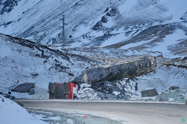
At the Tuy Ashu Pass, a vehicle with a fuel oil tanker overturned.

Coordinates: Latitude 42°22"10.2954" Longitude 73°48"48.85092" On January 21, 2022, a report was received from an environmental activist about another accident at the Tuy Asha pass. A vehicle carrying a tank of fuel oil overturned. The video sent illustrated streams of fuel oil flowing down the slope towards the Obla River. This river flows into the Kara-Balta River, which then merges into the transboundary Chu River. This river system is a source of drinking water for the

Deforestation

The park is being destroyed in the only cardiology sanatorium in Kyrgyzstan.

Coordinates: Latitude 42°41.8964 Longitude 74°32.2616 A unique park of the cardiological sanatorium of Kyrgyzstan is being destroyed. Under the guise of deadwood and emergency trees, healthy trees are being cut down, including those that have a special environmental protection status in the country (juniper). Activists from the villages of Tash-Dobo and Baytik are asking to save the only unique sanatorium in the country known for its healing properties. Without this recreational park, the

Water Pollution

On the Bishkek–Osh Road, a Fuel Tanker Overturned: A Leak of Oil Products into the River Occurred

42.622558, 73.891835 A traffic accident on the Bishkek–Osh road involving a fuel truck resulted in the death of a woman and contamination of the Kara-Balta River with petroleum products. On November 4, an accident occurred beyond the "Sosnovka" checkpoint. A 40-ton fuel truck loaded with fuel oil was traveling from the Jalal-Abad region. On the slippery road, the driver lost control, the vehicle overturned, and it crushed the rear part of a minivan. It later became clear that the fuel

Poaching (Animals)

Poaching. 89 illegal fishing nets with a total length of 8.9 km found in the Orto-Tokoy Reservoir.

In the Orto-Tokoy Reservoir, 89 poaching fishing nets with a total length of 8 kilometers and 900 meters have been discovered. According to information that has appeared in a number of media outlets, the bottom and shore of the Orto-Tokoy Reservoir are covered with fishing nets. The day before, employees of the Issyk-Kul and Naryn territorial departments of the environmental protection agency found 89 fishing nets with a total length of 8,900 meters in the Orto-Tokoy Reservoir. Additionally, 17

Poaching. A case of shooting a red-listed maral has been identified in the Sary-Chelek Nature Reserve.

Poaching: A case of illegal shooting of a red-listed maral has been identified in the Sary-Chelek Nature Reserve. On October 31, 2021, at approximately 18:30, employees of the Sary-Chelek Biosphere Reserve discovered a group of individuals at the "Tuur-Aryk" site who were butchering the carcass of a legally shot male maral, approximately five years old (determined by the traces on the skin). The violators turned out to be four residents of the village of Arkyt in the Aksy district.

Water Pollution

Village of Krasnaya Rechka. Discharge of waste from Tomat KG into the river. Fish are dying.

Coordinates: Latitude 42.886830 Longitude 74.981379 On August 13, 2021, residents of the village of Krasnaya Rechka in the Ysyk-Ata district of Chui region contacted the editorial office of the project "Ecomap.kg" via WhatsApp with a problem. According to them, a canning factory of the agricultural enterprise "Tomat.kg" has been operating here for several years. Local residents have noticed that the dirty wastewater with production waste is repeatedly discharged into a

Son-Kul Pasture Degradation. Overgrazing.

Coordinates: Latitude 41°887674 Longitude 75°220811 The high-altitude pastures of Son Kol are located near Lake Son Kol and cover an area of 108,000 hectares. These pastures are ancient and primarily serve the local population of 100,000 through livestock farming, which constitutes 70% of agricultural income. Currently, the practice of land use is leading to an increase in the degradation of land resources due to overgrazing, with the spread of non-food grasses, and an annual decline in

Poaching (Animals)

Maximum Water Release from the Ala-Archa_3 Reservoir. Fish Death

Coordinates: Latitude 43° 013943 Longitude 74° 616742 Summer 2021 was dry for all of Kyrgyzstan. However, the consequences of the water shortage are most acutely felt in the Chui region. Currently, the entire territory of the Chui Valley can be considered, in one way or another, as a zone of ecological disaster and ecocide. According to specialists, the "Spartak" reservoir used to host the largest number of fish species in the Chui region and in Kyrgyzstan as a whole during "good

Landfill

Spontaneous Dump Murass-Ordo-Stepnoye-Ozyornoye.

Coordinates: Latitude 42°945110 Longitude 74°543171 Semi-wild dumps are one of the significant factors of pollution that negatively impact natural components: the atmosphere, water sources, soil, and flora and fauna. By being placed directly on the soil cover, dumps remove a substantial part of the land from agricultural use and the biosphere, introducing pollutants into them. When waste placed in unauthorized dumps ignites, toxic and poisonous substances are released into the atmosphere.

Landfill

Spontaneous Dump of the Village Dachi-SU_2

Coordinates: Latitude 43°057030 Longitude 74°433575 Semi-illegal dumps are one of the significant factors of pollution, negatively impacting natural components: the atmosphere, water sources, soil, and plant and animal life. By being placed directly on the soil cover, dumps remove a significant portion of land from agricultural circulation and the biosphere, introducing pollutants into them. When waste placed in unauthorized dumps ignites, toxic and harmful substances are released into the

Продолжая просматривать сайт ecomap.kg вы принимаете правила сайта.
ОК
[/not-static]

Embed the map on your site

Just copy this code and paste it on your website. The map will update automatically.