EcoMap.kg » Incidents » Page 37
Industrial Mining

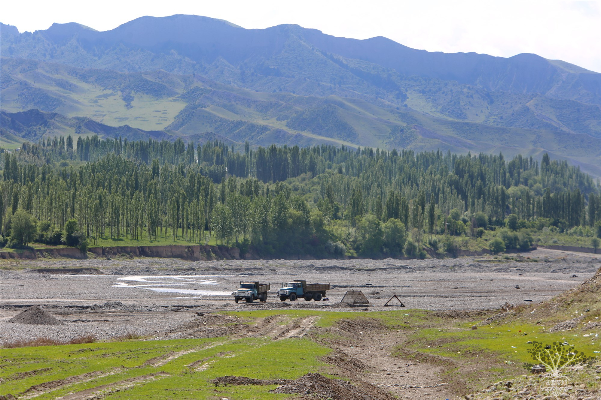
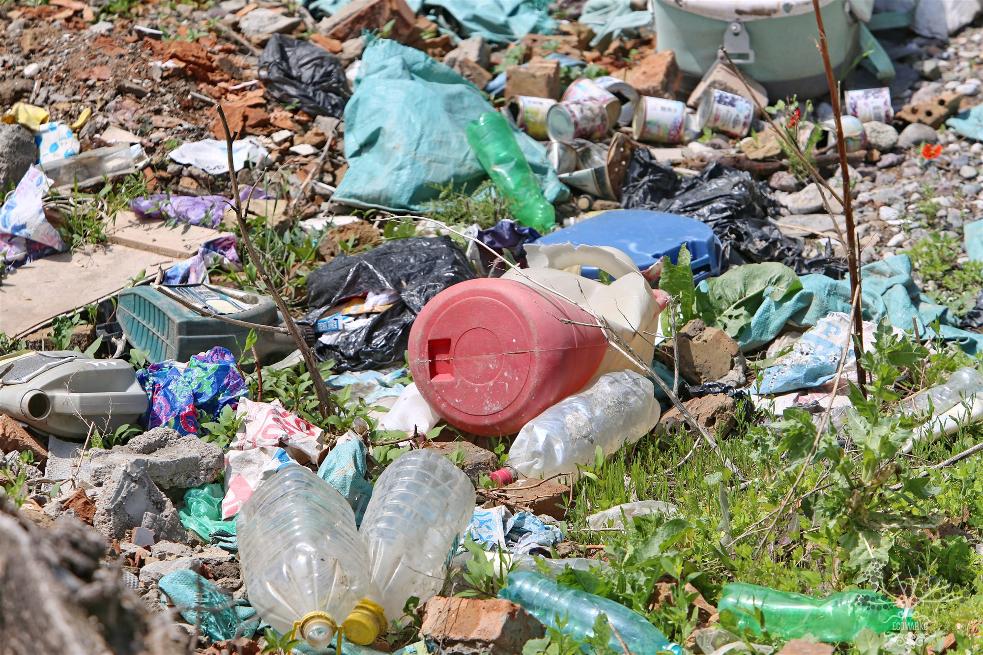
Extraction of inert materials in the riverbed of the Ak-Buura River. Papan Water Reservoir

Coordinates: 40.353807, 72.942418 On the Ak-Buura River. Illegal extraction is taking place at the Papan Reservoir, where local residents use sand and gravel material for their construction or private homes. Unfortunately, there is no perfect methodology to accurately calculate the damage caused to the environment by illegal extraction. However, this does not mean that the damage is insignificant, as the extraction of gravel-sand mixtures in the river disrupts the riverbed, creates pits, and

Water Pollution

Illegal Dumpsites on the Shore of the Papan Reservoir

Coordinates: 40.364234, 72.909168 Any unauthorized dump is not only very unaesthetic but also dangerous. Each such pile is a kind of chemical laboratory, producing harmful toxins and spreading polluted substances around itself. Atmospheric precipitation, passing through heaps of garbage like a filter, enters the soil and then into underground waters, rivers, and lakes, altering their chemical and physical composition. An unauthorized dump, like a legal one, is a real breeding ground for

Landfill

Spontaneous Dump of the Villages Pachtachy - Koichubaevo - Agronom

Coordinates: 40.481801, 72.449840 Landfills are one of the significant factors of pollution that negatively impact natural components: the atmosphere, water sources, soil, and plant and animal life. By being placed directly on the soil cover, landfills remove a significant portion of land from agricultural circulation and the biosphere, introducing pollutants into them.

Extraction of inert materials. On the Aravan-Sai River. Kerek

Coordinates: 40.450312, 72.583126 Illegal extraction is taking place on the Aravan-Sai River, where local residents use sand and gravel material for their construction projects or private homes. Unfortunately, there is no perfected methodology that allows for an accurate assessment of the environmental damage caused by illegal extraction. However, this does not mean that the harm is insignificant, as the extraction of gravel and sand mixtures from the river disrupts the riverbed, creates pits,

Landfill

Spontaneous Dump, Ravine, and Dangi Pass

Coordinates: 40.353080, 72.596413 Landfills are one of the significant factors of pollution, negatively impacting natural components: the atmosphere, water sources, soil, and plant and animal life. By being placed directly on the soil surface, landfills remove a significant portion of land from agricultural use and the biosphere, introducing pollutants into them.

Landfill

Spontaneous Dump. Dry Sai. Tuya-Muyun

Coordinates: 40.351194, 72.602976 Landfills are one of the significant factors of pollution, negatively impacting natural components: the atmosphere, water sources, soil, and plant and animal life. By being placed directly on the soil surface, landfills remove a significant portion of land from agricultural circulation and the biosphere, introducing pollutants into them.

Radiation

Radiological Situation in the Area of the Former Radium Mine "Tuya-Muyun". Fersman Cave

Coordinates: 40.357283, 72.585779 The Tuyamuyun massif is a latitudinally elongated block of Lower Carboniferous massive limestones up to 600 m wide. The limestones are almost vertically inclined, broken into blocks, marbleized, brecciated, and cut by calcite veins. They are trapped between the rocks of the Paleozoic strata (coal and clay shales, sandstones, siliceous shales, effusive rocks), separated from them by faults. The surface of the massif is a gently sloping plateau to the north with

Radiation

Radiological Situation in the Area of the Former Radium Mine "Tuya-Muyun". Large Barite Cave.

Coordinates: 40.353084, 72.597273 The Tuyamuyun massif is a latitudinally elongated block of Lower Carboniferous massive limestones, up to 600 m wide. The limestones are almost vertically inclined, broken into blocks, marbleized, brecciated, and cut by calcite veins. They are trapped between Paleozoic strata of interbedded rocks (carbonaceous and clayey shales, sandstones, siliceous shales, effusive rocks), separated from them by faults. The surface of the massif represents a gently sloping

Radiation

Radiological Situation in the Area of the Former Radium Mine "Tuya-Muyun". Unreclaimed Shaft.

Coordinates: 40.353665, 72.609550 The Tuyа-Muyun massif is a latitudinally elongated block of Lower Carboniferous massive limestones, up to 600 m wide. The limestones are almost vertically inclined, broken into blocks, marbleized, brecciated, and cut by calcite veins. They are squeezed between Paleozoic strata of interbedded rocks (coal and clay shales, sandstones, siliceous shales, effusive rocks), separated from them by faults. The surface of the massif is a gently sloping plateau to the

Water Pollution

Pollution and Contamination of the Andijan-Say River, Dangi Canyon

Coordinates: 40.353414, 72.610113 Any unauthorized dump is not only very unaesthetic but also dangerous. Each such pile is a kind of chemical laboratory, producing harmful toxins and spreading contaminated substances around it. Atmospheric precipitation, passing through heaps of garbage like a filter, enters the soil and then into underground waters, rivers, and lakes, altering their chemical and physical composition. An unauthorized dump, like a legal one, is a real breeding ground for

Продолжая просматривать сайт ecomap.kg вы принимаете правила сайта.
ОК
[/not-static]

Embed the map on your site

Just copy this code and paste it on your website. The map will update automatically.